
I still remember the call from a Part 107 pilot in Colorado who thought he was flying legally at exactly 400 feet. His controller said 400 feet on the dot. The problem? He launched from a ridge at 9,200 feet elevation, and his barometric altimeter was locked to the takeoff point. By the time he flew out over the valley to inspect a transmission tower, his drone was actually at roughly 1,600 feet above the terrain below. A passing helicopter crew spotted him on ADS-B. That phone call is exactly why this guide exists.
The 400-foot rule sounds simple. Drone pilots must fly no higher than 400 feet above ground level (AGL). But AGL is where pilots get tripped up. Your drone’s controller usually measures altitude from where you took off, not from the ground directly beneath the aircraft. In flat Kansas wheat fields, those numbers match. In the mountains of Utah, Colorado, or California, they can be off by hundreds of feet. That’s the silent failure mode behind most altitude violations, and it is exactly what I want to walk you through today.
In this guide, I’ll break down what the 400-foot rule actually says in FAA regulation, why the FAA chose that number, and the precise mechanism by which AGL confuses otherwise careful pilots. I’ll cover the Part 107 structure exception, legal pathways to fly higher, terrain pitfalls, tools that keep you honest, and what the FAA actually does when pilots break the rule. By the end, you’ll have a clear mental model for altitude compliance that goes beyond memorizing a number.
Table of Contents
What Is the 400-Foot Rule for Drones?
The 400-foot rule is an FAA regulation that prohibits drone pilots from flying higher than 400 feet above ground level (AGL) unless a specific exception applies. For Part 107 commercial pilots, this rule is codified at 14 CFR 107.51(b). For recreational flyers, the same 400-foot AGL ceiling is required under 49 USC 44809, the law that restored recreational flying under Section 336 of the FAA Modernization and Reform Act of 2012.
The FAA picked 400 feet AGL to keep a 100-foot safety buffer between drones and manned aircraft. Under 14 CFR 91.119, manned aircraft must fly no lower than 500 feet above the surface in uncongested areas. So if a drone stays at or below 400 feet AGL, there is at least 100 feet of vertical separation from the lowest legal altitude of a manned airplane or helicopter. That buffer is the entire reason the rule exists.
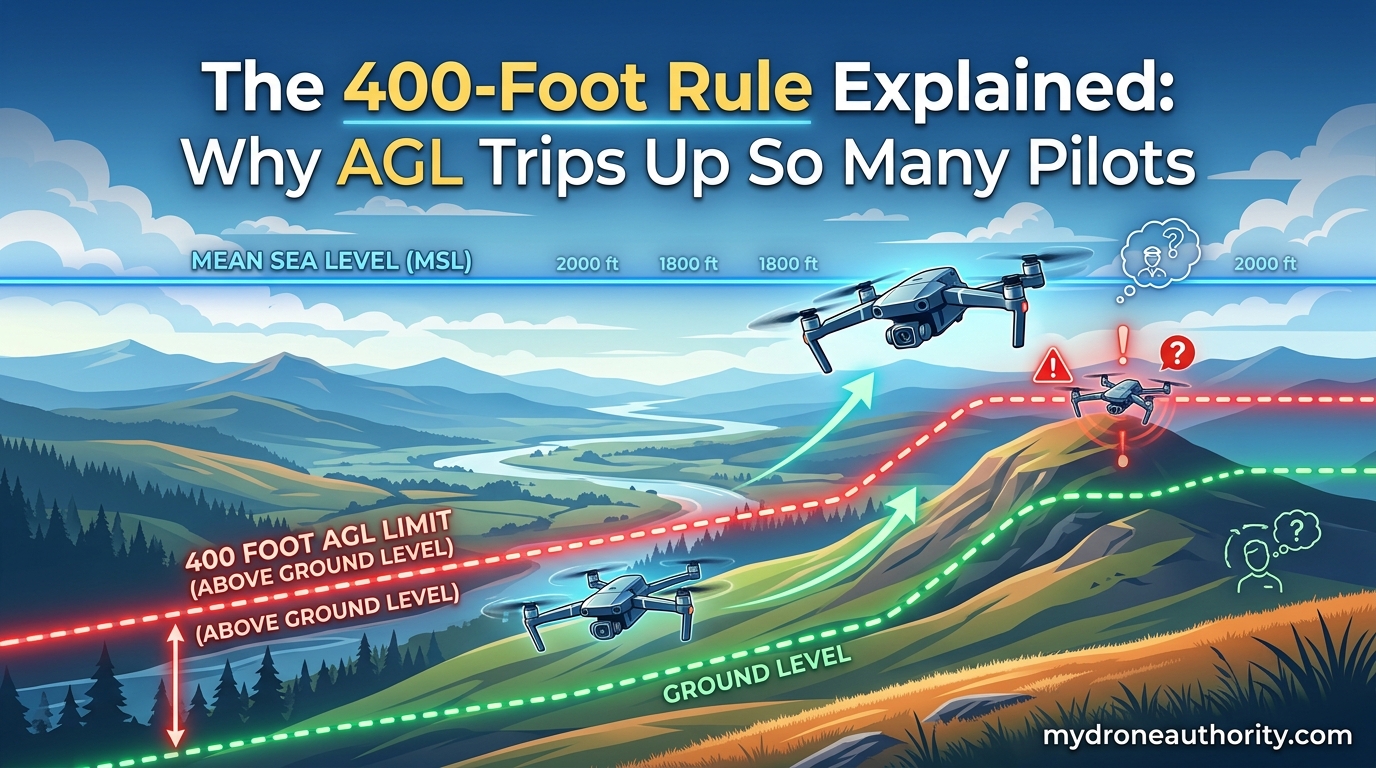
Where pilots get tripped up is the AGL part. AGL means altitude measured from the ground, terrain, or structure directly beneath the aircraft. It is not altitude measured from your takeoff point, and it is not altitude measured from sea level. The FAA does not care where you took off. The FAA cares where the ground is below your drone at any given moment.
AGL vs MSL: The Difference That Trips Up Pilots
AGL (above ground level) measures altitude from the surface directly beneath the aircraft. MSL (mean sea level) measures altitude from a standardized average sea level datum that geographers and aviators have used since the 19th century. Both numbers describe altitude, but they describe altitude relative to different reference points, and only one of them matters for drone compliance.
The FAA regulates drones based on AGL, not MSL. This is a deliberate choice. Manned aircraft are tracked on MSL because they need consistent separation across varying terrain. Drones are tracked on AGL because they hug the surface. A drone flying at 400 feet AGL over a 14,000-foot mountain peak is at 14,400 feet MSL. That drone is perfectly legal, even though no manned aircraft would be anywhere near that altitude.
The catch is that most consumer drone controllers do not display true AGL. They display altitude relative to your takeoff point using a barometric altimeter, which is a sensor that estimates altitude by measuring air pressure. Air pressure decreases as altitude increases, so the controller can estimate how high it is above your launch site by tracking pressure changes. Some modern drones also fuse in GPS altitude readings. Either way, the number on your screen is not necessarily your true AGL over the terrain below.
Picture a drone launched from a valley floor at 6,000 feet MSL. The pilot flies the drone straight up a mountainside. The controller reads 400 feet when the drone is at 6,400 feet MSL. But if the drone is hovering 200 feet above the slope directly beneath it, the true AGL is only 200 feet. As the drone continues up the slope, the controller still reads 400 feet. The true AGL over the ground below might be 800 feet by the time the drone reaches a ridgeline. That is a violation, even though the pilot never saw the controller read anything above 400 feet.
This is the central confusion. Most pilots assume “what the controller says” equals AGL. It usually doesn’t, especially in terrain.
Who Must Follow the 400-Foot Rule?
Every drone pilot operating in the United States National Airspace System must follow the 400-foot AGL limit, but the rules differ depending on whether you fly for fun or for work. Public safety pilots and certain other operators also have their own carve-outs.
Recreational flyers fly under 49 USC 44809, the statute that governs hobbyist drone operations. The 400-foot AGL ceiling applies, and recreational flyers must also pass the free TRUST test (The Recreational UAS Safety Test), register their drone if it weighs more than 0.55 pounds, and follow the safety guidelines of a Community-Based Organization such as the Academy of Model Aeronautics.
Part 107 commercial pilots fly under 14 CFR Part 107, the FAA’s small UAS rule. They must hold a Remote Pilot Certificate, which requires passing the Part 107 knowledge test at an FAA-approved testing center. Part 107 pilots are bound by 14 CFR 107.51(b), which sets the 400-foot AGL ceiling and creates the structure exception that recreational flyers do not get. Part 107 pilots also have access to LAANC, the Low Altitude Authorization and Notification Capability, which lets them request real-time airspace authorization in controlled airspace.
Public safety pilots are Part 107-certified operators conducting operations for emergency response, law enforcement, or firefighting. Under 14 CFR 107.1(b)(4), public safety operations can be conducted under a Certificate of Waiver or Authorization (COA) instead of Part 107, and those COAs sometimes permit altitudes above 400 feet AGL for specific missions like wildfire mapping or search and rescue. Public safety pilots still default to Part 107 rules when no COA covers their operation.
The 400-foot rule covers all three categories. The exceptions, enforcement, and flexibility around it differ significantly.
Why Did the FAA Choose 400 Feet AGL?
The FAA picked 400 feet AGL because of one specific regulation: 14 CFR 91.119. That rule sets minimum safe altitudes for manned aircraft. In uncongested areas, manned aircraft must fly at least 500 feet above the surface. The 100-foot gap between 400 feet AGL (drone ceiling) and 500 feet AGL (manned aircraft floor) is the entire safety rationale.
The FAA’s Reauthorization Act of 2018 confirmed this logic. Congress directed the FAA to treat small UAS operations under Part 107 as compatible with the existing airspace structure, and the 400-foot AGL ceiling emerged from the FAA’s effort to integrate drones without disrupting manned aviation. The same logic applies to recreational flyers under 49 USC 44809, which simply reauthorized hobbyist flying under existing airspace rules.
There is also a practical reason. Small consumer drones have limited radio range, limited battery life, and limited visual conspicuity. A 400-foot AGL ceiling keeps drones close enough to the Remote Pilot-in-Command for visual line of sight (VLOS), which is itself a separate FAA requirement under 14 CFR 107.31. Going higher would make VLOS harder, controller links less reliable, and collisions with terrain features more likely.
The number is not arbitrary. It is the exact altitude that maintains the FAA’s 100-foot vertical safety buffer between the highest legal drone altitude and the lowest legal manned aircraft altitude. When you fly at 400 feet AGL, you are flying at the ceiling of what the FAA considers safe coexistence with manned traffic.
The 400-Foot Structure Exception (Part 107 Only)
Part 107 pilots get a special exception that recreational flyers do not. Under 14 CFR 107.51(b)(1), a Part 107 Remote Pilot-in-Command can fly up to 400 feet above the top of a structure, as long as the drone stays within a 400-foot horizontal radius of the structure and does not fly higher than 400 feet above the structure’s uppermost limit.
This exception exists because infrastructure inspection is one of the most common commercial drone use cases. Inspecting a 350-foot cellular tower, a 250-foot wind turbine, or a 600-foot skyscraper would be impossible under a flat 400-foot AGL cap. The FAA recognized this and built in the structure exception specifically for those operations.
The structure must be a man-made structure. Buildings, towers, bridges, and turbines all qualify. Natural features like hills, cliffs, and ridgelines do not. There is ongoing industry debate about whether cranes, construction scaffolding, or temporary structures count, and the FAA has issued guidance saying the determination depends on whether the structure is fixed and permanent enough to have a defined top. A working construction crane generally does qualify if it is anchored and stable.
To use the exception, the Remote Pilot-in-Command must be able to determine the height of the structure with reasonable accuracy. That usually means reviewing the structure’s design plans, surveying data, or a published height. The drone must remain within 400 horizontal feet of the structure at all times. If the drone drifts outside that radius, the 400-foot AGL ceiling snaps back into force immediately.
The Droning Company published a great breakdown of use cases for this exception, including cellular tower inspection, wind turbine surveys, bridge inspection, and skyscraper facade work. We agree with their analysis that the structure exception is one of the most valuable tools for Part 107 pilots doing industrial work, but it requires careful mission planning and reliable altitude measurement to stay inside the rules.
Legal Pathways to Fly Above 400 Feet AGL
There are four legal pathways for pilots who need to operate above 400 feet AGL. Each has specific eligibility rules, application steps, and operational limits.
Part 107 altitude waiver (14 CFR 107.200): A waiver lets a Part 107 pilot request an exception to one or more operating rules, including the 400-foot AGL ceiling. Waivers are granted for specific operations in specific geographic areas for up to four years. Common waiver use cases include tall-structure inspection, agricultural operations over orchards, and surveying in mountainous terrain. The application goes through the FAA DroneZone and requires a detailed safety case showing equivalent or greater safety compared to the rule being waived.
LAANC authorization: The Low Altitude Authorization and Notification Capability provides near-real-time airspace authorization for Part 107 pilots operating in controlled airspace below the approved altitude ceiling for that airspace. LAANC does not authorize altitudes above 400 feet AGL in Class B, C, D, or surface E airspace around airports. It authorizes flight in airspace that would otherwise be off-limits without ATC permission. If a UAS Facility Map shows a grid altitude of 100 feet for a given area, LAANC will only authorize up to 100 feet AGL there.
FRIA operations: A FAA-Recognized Identification Area (FRIA) is a fixed geographic location where recreational flyers can operate without broadcasting Remote ID. FRIAs are designated by community-based organizations or educational institutions and must be registered with the FAA. FRIAs do not grant altitude exceptions. The 400-foot AGL ceiling still applies.
Public safety COA: Public safety agencies can apply for a Certificate of Waiver or Authorization that permits operations above 400 feet AGL for specific missions. Wildfire mapping, search and rescue, and disaster response are common COA use cases. COAs are negotiated directly between the agency and the FAA.
For most pilots, an altitude waiver is the only realistic path above 400 feet AGL. The application process takes 60 to 90 days and requires a robust safety case. We have seen pilots succeed by citing specific mission requirements, demonstrating redundant safety mitigations, and coordinating with local ATC.
Terrain and Altitude Measurement Pitfalls
This is the section of the article I wish every drone pilot would read before their first mountain flight. The single biggest source of 400-foot AGL violations is not intentional rule-breaking. It is pilots trusting the wrong altitude reading in terrain they did not fully understand.
Barometric altimeter drift: Barometric altimeters estimate altitude by measuring air pressure. Air pressure changes with weather and temperature, not just altitude. A barometric altimeter that was calibrated at takeoff can drift several feet per minute as weather conditions shift. Over a 20-minute flight in changing conditions, the altimeter can be off by 30 to 100 feet. In mountainous terrain where pressure gradients are steeper, the drift can be even larger.
GPS altitude errors: GPS altitude is calculated from satellite geometry, not pressure. It is generally more accurate than barometric altitude over long distances, but it has its own quirks. Standard consumer GPS receivers have vertical accuracy of about 15 to 30 feet under ideal conditions. Multipath errors near cliffs, canyon walls, or tall buildings can push the error to 50 feet or more. Below the tree canopy or in narrow canyons, satellite reception drops and altitude readings can become unreliable.
Negative altitude readings: Pilots in valleys regularly report their controller showing negative altitude numbers. This happens when the drone is below the takeoff point in elevation. If you launch from a ridge and fly your drone down into a valley, your barometric altimeter is reading altitude above the ridge, not above the terrain directly beneath the drone. The controller might show -150 feet when the drone is hovering 50 feet above the valley floor. The pilot assumes they are deep in the negative and well below 400 feet AGL. They are actually at 50 feet AGL, fully compliant. But the same scenario can mislead pilots the other way.
Mountain and valley flying: Launching from a valley floor and flying up a mountain is the classic AGL trap. The pilot sees 400 feet on the controller when the drone is at the ridge. By then, true AGL over the slope below could be 600 feet or more. The pilot sees 400 feet when they are already in violation. There is no warning, no alarm, no visible indication of trouble. The drone just keeps climbing in MSL while the controller keeps reporting altitude relative to a takeoff point that is now far below the aircraft.
How to manage true AGL in terrain: The best practice is to combine multiple data sources. Use a current terrain elevation map (USGS or a similar service) to identify your takeoff elevation and the elevation of any terrain you intend to fly over. Calculate your true AGL by subtracting terrain elevation from your drone’s MSL altitude reading, which is reported by GPS. Set conservative RTH (return-to-home) altitudes well above the highest terrain in your flight area. And when in doubt, fly lower than you think you need to.
Tools and Apps for Staying Compliant
A handful of free and paid tools make 400-foot AGL compliance much easier. Every pilot should have at least the first two on their phone or tablet before every flight.
B4UFLY: The FAA’s official airspace awareness app. B4UFLY shows controlled airspace, Class B/C/D boundaries, restricted areas, and the UAS Facility Maps that determine LAANC grid ceilings. It does not show terrain, but it tells you what altitudes LAANC will authorize in your area.
Aloft (formerly Kittyhawk): A commercial airspace and LAANC app with better terrain visualization than B4UFLY. Aloft integrates with DJI drones for live airspace status and offers paid team-management features for commercial operators.
DJI geofencing change (January 2025): This is the single most important altitude-compliance story of 2026. In January 2025, DJI removed automatic altitude and zone restrictions from its consumer and enterprise drones. Prior to that date, DJI drones physically prevented pilots from flying above 400 feet AGL or into NFZ (no-fly zone) areas without an unlock. After the change, DJI drones trust the pilot to comply with all regulations. This means pilots who relied on firmware limits as a safety net no longer have one. The FAA did not change its rules. DJI simply stopped enforcing them in firmware.
Airdata UAV: A flight logging and analysis platform that captures detailed altitude, GPS, and battery data from each flight. Airdata overlays your flight track on a map and lets you verify your AGL compliance after the fact. It is the easiest way to confirm you stayed under 400 feet AGL throughout an entire mission.
Controller alarms and RTH settings: Most modern drone controllers let you set altitude warning alarms and RTH altitudes. Set the warning alarm to 350 feet AGL so you get a heads-up before you reach the limit. Set RTH above the highest terrain feature in your flight area by at least 100 feet. These two settings alone eliminate most accidental altitude excursions.
Consequences of Violating the 400-Foot Rule
The FAA treats 400-foot AGL violations seriously, especially for Part 107 commercial pilots. The enforcement tools range from advisory letters to multi-thousand-dollar civil penalties.
FAA fines and civil penalties: The FAA can issue civil penalties up to $27,500 per violation for Part 107 pilots and up to $75,000 per violation for recreational flyers operating dangerously. The FAA uses a risk-based approach, so a first-time offender who flew 450 feet AGL over open farmland is likely to receive a counseling letter rather than a fine. A pilot who flew 800 feet AGL near a helicopter route will likely face a much larger enforcement action.
Part 107 certificate suspension or revocation: Under 14 CFR 107.19, the FAA can suspend or revoke a Remote Pilot Certificate if the pilot demonstrates a lack of competency, carelessness, or recklessness. Repeated or egregious altitude violations can lead to certificate action. A pilot who loses their Part 107 certificate cannot legally fly drones commercially until they reapply and retake the knowledge test.
Insurance and liability implications: Most drone liability policies require compliance with all applicable FAA regulations. A 400-foot AGL violation could void coverage in the event of a claim. If the drone damages property or injures someone while in violation, the pilot could face full personal liability for damages that insurance would otherwise have covered.
Operational consequences: Beyond formal FAA action, an altitude violation can result in the loss of client contracts, denial of future waivers, and a permanent mark on the pilot’s enforcement record with the FAA. The DroneZone system tracks all Part 107 enforcement actions, and they remain visible to FAA inspectors reviewing future waiver applications.
The bottom line is that the FAA treats altitude violations as evidence of pilot competency. A single violation may not end a drone career, but a pattern of violations will.
Pre-Flight Checklist for Altitude Compliance
Use this checklist before every flight to confirm you will stay at or below 400 feet AGL throughout the mission.
- Check the takeoff point elevation using USGS data, Google Earth, or a GPS app.
- Identify the highest terrain feature within your planned flight area and note its elevation.
- Calculate your maximum MSL altitude by adding 400 feet to the highest terrain elevation in your area.
- Set your controller altitude warning alarm to 350 feet AGL.
- Set your RTH altitude to at least 100 feet above the highest terrain feature in your area.
- Verify B4UFLY or Aloft airspace status and any LAANC grid ceiling for your location.
- If using the Part 107 structure exception, confirm the structure height and your 400-foot horizontal radius plan.
- Recalibrate the barometric altimeter immediately before takeoff for accurate baseline readings.
- During flight, monitor both barometric altitude and GPS altitude displayed on your controller.
- After flight, review your Airdata or controller flight log to confirm AGL compliance throughout the mission.
This checklist takes about 10 minutes per flight. The pilots I have coached who use it consistently have zero altitude violations on their records.
Frequently Asked Questions About the 400-Foot Rule
What does 400 ft AGL mean for drone pilots?
400 ft AGL means 400 feet above the ground directly beneath your drone. The FAA measures drone altitude from the terrain below the aircraft, not from your takeoff point and not from sea level. Under 14 CFR 107.51(b), Part 107 pilots must fly no higher than 400 feet above the ground beneath them unless they qualify for an exception.
Why can’t I fly my drone above 400 feet?
You cannot fly above 400 feet AGL because manned aircraft are required to fly no lower than 500 feet above the surface in uncongested areas under 14 CFR 91.119. The 100-foot gap between the drone ceiling and the manned aircraft floor is the FAA’s safety buffer to prevent mid-air collisions. Going above 400 feet AGL erodes that buffer and creates collision risk.
What is the 70/50 rule for drones?
The 70/50 rule is a colloquial reference to Part 107 operations over people (OOP) and over moving vehicles. Under 14 CFR 107.145, Part 107 pilots can operate over people using Category 1-4 drones subject to specific weight, altitude, and operational limits. The ’70/50′ shorthand comes from older FAA guidance on minimum altitude requirements for specific operations, but the operative rule for altitude is always 400 feet AGL.
What is the FAA 500 feet rule?
The FAA 500 feet rule is the minimum altitude for manned aircraft under 14 CFR 91.119. In uncongested areas, manned aircraft must fly at least 500 feet above the surface. The drone 400-foot AGL ceiling is set 100 feet below this manned aircraft floor to create a vertical safety buffer between drones and crewed aviation.
Can I fly above 400 feet if I am near a building?
Part 107 pilots can fly above 400 feet AGL within 400 horizontal feet of a structure, up to 400 feet above the structure’s top. This is the structure exception under 14 CFR 107.51(b)(1). Recreational flyers do not get this exception and must stay at or below 400 feet AGL regardless of nearby buildings.
What happens if I fly my drone above 400 feet AGL?
The FAA can issue civil penalties up to $27,500 per Part 107 violation and up to $75,000 for recreational operations. The FAA can also suspend or revoke your Part 107 Remote Pilot Certificate under 14 CFR 107.19. Insurance coverage may be voided if a violation is on record.
Does DJI still block flying above 400 feet after the January 2025 change?
No. In January 2025, DJI removed automatic altitude and zone restrictions from its drones. DJI drones no longer physically prevent pilots from exceeding 400 feet AGL. Pilots must self-enforce the FAA altitude rule. The FAA’s regulation has not changed, but DJI’s firmware-level enforcement has been removed.
How do mountains and valleys affect the 400-foot rule?
Mountains and valleys create AGL compliance challenges because barometric altimeters measure altitude relative to the takeoff point, not the terrain below the drone. A pilot launching from a valley and flying up a mountainside may see 400 feet on the controller while the true AGL over the slope below is 600 feet or more. Combine barometric altitude with GPS altitude and terrain maps to maintain compliance.
Do recreational pilots have any exceptions to the 400-foot rule?
No. Recreational flyers under 49 USC 44809 must stay at or below 400 feet AGL. They do not get the Part 107 structure exception, and they cannot request a Part 107 altitude waiver. Recreational pilots must follow CBO safety guidelines and the 400-foot AGL ceiling at all times.
How do I request a Part 107 altitude waiver?
You request a Part 107 altitude waiver through the FAA DroneZone portal under 14 CFR 107.200. The application requires a detailed safety case showing that your proposed operation will achieve equivalent or greater safety compared to the 400-foot AGL rule. FAA review typically takes 60 to 90 days. Common waiver use cases include tall-structure inspection and agricultural operations in mountainous terrain.
Final Thoughts on the 400-Foot Rule and AGL
The 400-foot rule is one of the simplest drone regulations to read and one of the hardest to follow correctly. The number is unambiguous: 400 feet above ground level. The reference point is where pilots get tripped up. AGL measures altitude from the terrain directly beneath your drone, not from your controller’s barometric reading and not from sea level.
If you remember nothing else from this guide, remember this: in flat terrain, your controller is a reliable AGL proxy. In mountainous terrain, your controller is not. Use GPS altitude, terrain maps, controller alarms, and conservative RTH settings to bridge the gap between what your drone thinks its altitude is and what your true AGL actually is. The DJI geofencing change in January 2025 removed the last firmware-level safety net. Self-enforcement is now the only enforcement for many pilots.
Stay under 400 feet AGL, plan for terrain, and treat every flight as an opportunity to verify your readings with multiple data sources. That habit is what separates pilots who never get a violation letter from pilots who do.